orca-robotics
INTRODUCTION
Overview
Download and Install
Quick Start
Documentation
Publications
REPOSITORY
Interfaces
Components
Libraries
Utilities
Software Map
DEVELOPER
Tutorials
Examples
Dev Guide
Dashboard
Wiki
login/pass: orca/orca
PEOPLE
Contributors
Users
Project
Download
Mailing lists
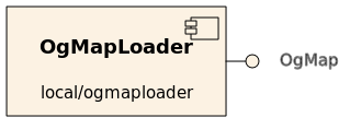
OgMapLoader
[Components, Stand-Alone Components, C++, Linux, QNX]
Serves an occupancy grid map which is loaded from an image file.
More...- Provides
- Requires
- none

- Drivers
- fake Serves a bogus made-up map.
- file Loads an occupancy grid map from a file.
- Operation
- most image formats
- anything qt can load:
.png.bmp.jpg.jpeg.ppm.xbm.xpm
- anything qt can load:
- ICE stream files
- file extension:
.bin - these files can be generated using OrcaView2d
- file extension:
Clients who wish to receive the map should call getData(). This component will only ever issue one update to subscribers: on initialisation.
- Configuration
OgMapLoader.Config.Driver(string)- Which map loader to use
- Valid values: { "file", "fake" }
- Default: "file"
OgMapLoader.Config.Filename(string)- The name (and path) of the image to load
- Default: "mapfile.png"
OgMapLoader.Config.Negate(bool)- Whether increasing pixel value represents increasing occupancy probability
- Valid Values:
- 0: black is occupied, white is empty
- 1: white is occupied, black is empty
- Default: 0
OgMapLoader.MapType(int)- Used to determine what the served ogMap represents
- Values: 0:occupancy, 1:hazard, 2:motion, user-defined integers can be assigned
- Default: 0
Map Geometry (see OgMap for a detailed explanation)
Note: These parameters have no effect on maps loaded from ICE stream files. Those files contain all relevant information already.
World Size (float,float) [m]
OgMapLoader.Config.Size.XOgMapLoader.Config.Size.Y
Map Origin with respect to the (arbitrarily defined) global coordinate system (float,float,float) [m,m,deg]
OgMapLoader.Config.Offset.XOgMapLoader.Config.Offset.YOgMapLoader.Config.Offset.Orientation
For example, these configuration settings work for the Player's famous cave world. We define the global coordinate system's origin to be in the centre of the map.
OgMapLoader.Config.Driver=file
OgMapLoader.Config.MapFileName=cave.png
OgMapLoader.Config.Negate=0
OgMapLoader.Config.Offset.Orientation=0.0
OgMapLoader.Config.Offset.X=-8.0
OgMapLoader.Config.Offset.Y=-8.0
OgMapLoader.Config.Size.X=16.0
OgMapLoader.Config.Size.Y=16.0
Dependancies
- Qt GUI library >= v.4.1

 1.4.5
1.4.5