INTRODUCTION
Overview
Download and Install
Quick Start
Documentation
Publications
NONFRAMEWORK CODE
Driver Interfaces
Drivers
Libraries
Utilities
FRAMEWORK CODE
Interfaces
Components
Libraries
Utilities
Full Software Listings
DEVELOPER
Tutorials
Examples
Dev Guide
Dashboard
PEOPLE
Contributors
Users
Project
Download
Mailing lists
OgMapLoader
[Components, Stand-Alone Components, C++, Linux, QNX]
Serves an occupancy grid map which is loaded from an image file. More...
Serves an occupancy grid map which is loaded from an image file.
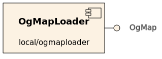
- Provides
- orca_interface_home
- orca_interface_ogmap [OgMapLoader.Provides.OgMap]
- orca_interface_status
- Requires
- none

- Drivers
- fake Serves a bogus made-up map.
- file Loads an occupancy grid map from a file.
- Operation
Supportes file types are:
- most image formats
- anything qt can load:
.png.bmp.jpg.jpeg.ppm.xbm.xpm
- anything qt can load:
- ICE stream files
- file extension:
.bin - these files can be generated using OrcaView2d
- file extension:
Clients who wish to receive the map should call getData(). This component will only ever issue one update to subscribers: on initialisation.
- Configuration
OgMapLoader.Config.Driver(string)- Which map loader to use
- Valid values: { "file", "fake" }
- Default: "file"
OgMapLoader.Config.Filename(string)- The name (and path) of the image to load
- Default: "mapfile.png"
OgMapLoader.Config.Negate(bool)- Whether increasing pixel value represents increasing occupancy probability
- Valid Values:
- 0: black is occupied, white is empty
- 1: white is occupied, black is empty
- Default: 0
OgMapLoader.MapType(int)- Used to determine what the served ogMap represents
- Values: 0:occupancy, 1:hazard, 2:motion, user-defined integers can be assigned
- Default: 0
Map Geometry (see orca_interface_ogmap for a detailed explanation)
Note: These parameters have no effect on maps loaded from ICE stream files. Those files contain all relevant information already.
World Size (float,float) [m]
OgMapLoader.Config.Size.XOgMapLoader.Config.Size.Y
Map Origin with respect to the (arbitrarily defined) global coordinate system (float,float,float) [m,m,deg]
OgMapLoader.Config.Offset.XOgMapLoader.Config.Offset.YOgMapLoader.Config.Offset.Orientation
For example, these configuration settings work for the Player's famous cave world. We define the global coordinate system's origin to be in the centre of the map.
OgMapLoader.Config.Driver=file
OgMapLoader.Config.MapFileName=cave.png
OgMapLoader.Config.Negate=0
OgMapLoader.Config.Offset.Orientation=0.0
OgMapLoader.Config.Offset.X=-8.0
OgMapLoader.Config.Offset.Y=-8.0
OgMapLoader.Config.Size.X=16.0
OgMapLoader.Config.Size.Y=16.0
Dependancies
- Qt GUI library >= v.4.1
Responsible Developer
Tobias Kaupp (t.kaupp at cas.edu.au)

 1.4.5
1.4.5